Why Toronto’s coat of arms features three rivers
Yinan Liu STAFF WRITER
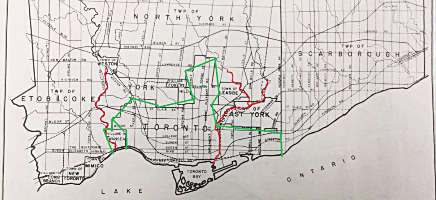
Photo: close-up of a 1961 map of Toronto (City of Toronto).
When you open up a map, you can see that Toronto is in a really nice place. Close to a huge water source, mostly flat land, has two rivers that flow through for industry and mills… wait a minute, two rivers? Then why there are three rivers shown on Toronto’s coat of arms?

This question really bothered me for a long time, and I was too lazy to google the answer. So naturally, I went to Robarts Library to see if I could find some old documents and maps that could explain this design. To my surprise, there were indeed only two rivers flowing through Toronto. The Humber River to the west of Toronto, and the Don River to the east. Where was the third one? The red line on this map from 1961 indicated rivers (left: Humber River, right: Don River), while the green line indicated Toronto’s rough outline. But the Humber River barely counts as part of the Toronto area, since it exists in the Village of Swansea.
The suspicion kept me going. I didn’t think it could be a mistake in the design of the coat of arms, since this logo was designed 20 years ago, and there was no way no one noticed the obvious mistake. Although there were three rivers to the north of Toronto, two of them merged into one before they entered the Toronto area, but there were clearly three different rivers flowing to the lake. “Could it be a tiny river, a creek, that was not labelled on the map?” I thought to myself. Then another map grabbed my eye. Yes, there was indeed a small creek — Black Creek, right next to the Humber River.

Could this be the middle river? Although it was just a creek, it still counted as “a natural stream of water flowing in a channel to the sea, a lake, or another such stream,” right? Excited, I followed the path of this creek. If it led directly to Lake Ontario, then we had all three rivers, live and flowin’.
Yet, disappointment quickly struck. Black Creek came to a sudden stop near Highway 401, and stopped existing on Wilson Street. Where did it go? It could have turned to an underground river — Toronto had plenty of construction happening in the past 10–20 years, and covering up a river is no hard work.
Again, I was wrong. The Black Creek did not end up underground. It continued to go south toward the river and suddenly turned west and joined the Humber River! What a troll!
I was properly confused. What is going on, where was the third river? What happened in the past 20 years that could make a river just disappear into thin air, with no trace or information? Was I mad? I NEEDED ANSWERS!!!
And answers I shall have. The map of Toronto was chronologically stacked from the newest on top to the oldest at the bottom. The one on the top had the answer I sought for two hours. This was what happened: zone amalgamation in 1998. Including North York, Etobicoke, East York, Scarborough, Old Toronto, current boundaries were defined, and right at the border was the third river — Rouge River.

Looking at this map, I finally understood why there are three rivers on the coat of arms. Humber, Don and Rouge Rivers have flowed through the Greater Toronto area, brought water sources, and provided power since 1998. Very nice. I just looked at an older map. The river didn’t disappear or go underground. It was in the wrong place. What a relief. Another mystery solved.
“Or,” I thought to myself as I took out my phone, “what if I google Toronto coat of arms…?” And there it was:
The coat of arms of Toronto, Ontario, Canada, was designed by Robert Watt, the Chief Herald of Canada at the time, for the city after its amalgamation in 1998. The arms were granted by the Canadian Heraldic Authority on January 11, 1999.
Oh boy. I guess googling was easier.